

There’s just something about those Colorado 14ers. Everybody wants to climb the highest mountains, and Colorado is loaded with them: 58 peaks rising higher than 14,000 feet. That’s more than any other state in the nation, including Alaska. Of those, 53 are officially ranked. The remaining five technically don’t rise 300 feet above a saddle between an adjacent peak, but most peak baggers aim to scale all 58 lofty summits anyway.
Hikers in Colorado Springs have a lengthy list of 14ers accessible within day trip range. There’s no such thing as an easy 14er, but in relative terms, some of the easiest 14ers in Colorado are nearby. So are some of the most crowded Colorado 14ers due to their proximity to Denver, the Springs and other Front Range cities.
Whether you’re a beginner just starting on your high elevation quest or an experienced mountaineer completing your last of Colorado’s highest peaks, here are 15 of the 14ers closest to Colorado Springs. And especially if you’re a beginner, don’t miss the 14er tips below. See you on the summits!
Note: Mileage is calculated from the heart of downtown to the most common trailheads for each peak. Drive times are approximate.
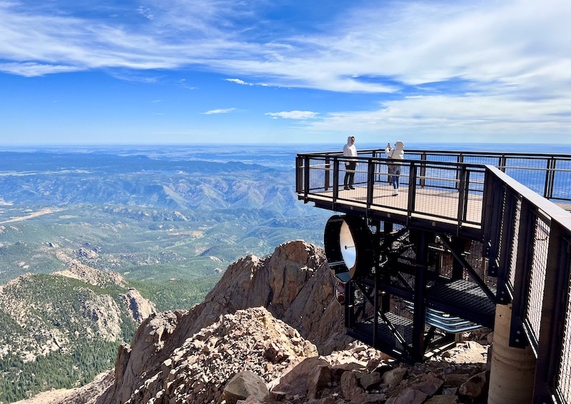
Pikes Peak
Distance from Colorado Springs: 9 miles
Estimated Drive Time: 20 minutes
Nearest Town to Trailhead: Manitou Springs, Colorado Springs
Summit: 14,115 feet
Pikes Peak is the Springs’ icon and America’s Mountain. Standing apart from any other 14ers, the wide massif dominates the local skyline. And there’s nowhere else you can get a fresh, hot donut at the summit. The classic Barr Trail starts in Manitou Springs, leading to a long 24-mile Class 1 journey that gains 7,600 feet. You can cut the length in half by arranging a ride down or catching one from a generous stranger. Or you can break up the trip with an overnight and breakfast at Barr Camp at 10,200 feet. If you want a shorter route, drive to the Crags Trailhead near Divide for a 14-mile roundtrip hike and generally less busy trail.

Mount Sherman
Distance from Colorado Springs: 94 miles
Estimated Drive Time: 2 hours
Nearest Town to Trailhead: Fairplay
Summit: 14,043 feet
This Class 1 Colorado 14 near Fairplay starts at the abandoned mining site of Leavick and passes other extractive ruins along the way. The classic route up the southwest ridge follows a closed mining road and rocky trail that gains 2,850 feet in 8.5 miles. Mount Sherman is considered one of the easiest 14ers in Colorado, though that is always a relative term. Views at the summit include fellow 14ers in the Mosquito Range and the long line of 14ers down the Sawatch Range, including the Collegiate Peaks and Colorado’s highest 14er, Mount Elbert.
The Decalibron: Mount Democrat, Mount Cameron, Mount Lincoln, Mount Bross
Distance from Colorado Springs: 95 miles
Estimated Drive Time: 2 hours
Nearest Town to Trailhead: Alma
Summits:
Mount Democrat 14,154 feet,
Mount Cameron 14,248 feet,
Mount Lincoln 14,293 feet,
Mount Bross 14,178 feet
Want to hike four 14ers at once? This is the unique spot to do the Decalibron between Alma and Breckenridge. (The name is a mashup of the four peak names. Get it?) After ascending Mount Democrat from the Kite Lake Trailhead, you’ll complete a loop of ridgelines connecting these four summits. Altogether the route covers 7.5 miles and gains 3,500 feet — totals often required for just one peak. After years with closures on some of these summits, landowners now allow public access once again — as long as you sign the digital liability waiver.
Mount Bierstadt
Distance from Colorado Springs: 98 miles
Estimated Drive Time: 2 hours 15 minutes
Nearest Town to Trailhead: Georgetown
Summit: 14,066 feet
Mount Bierstadt was officially Colorado’s busiest 14er in 2023, according to the Colorado Fourteeners Initiative’s most recent data, partly due to its accessibility from Denver and partly due to its relative gentle ascent. The standard Class 2 route up Bierstadt’s western slope gains 2,850 feet during its 7.25-mile roundtrip trek. You are above tree line from the start, so you can see the summit for much of the approach. Bierstadt’s notorious willows have sometimes been tricky to navigate in the past, but newer boardwalks help with the boggy area.
Quandary Peak
Distance from Colorado Springs: 98 miles
Estimated Drive Time: 2 hours 5 minutes
Nearest Town to Trailhead: Breckenridge
Summit: 14,272 feet
Quandary is the highest peak in the Ten Mile Range running from Frisco through Breckenridge. How to handle the crowds on the relatively easy peak in recent years has been the quandary. The solution is a paid reservation required to park at the Quandary Peak trailhead June 14 to Sept. 14. Or a cheaper option is to take a shuttle from Breckenridge. You can reserve both at hikequandary.com. On the mountain, the standard Class 1 route leads you up the east ridge, gaining 3,450 feet and covering 6.75 miles round trip.
Mount Princeton
Distance from Colorado Springs: 99 miles
Estimated Drive Time: 2 hours
Nearest Town to Trailhead: Nathrop, Buena Vista
Summit: 14,200 feet
Mount Princeton stands out as one of the most prominent of the Collegiate Peaks lining the Arkansas River Valley above Buena Vista. You can see it clearly from Pikes Peak, Divide and Wilkerson Pass. The standard route up Princeton’s eastern slopes is a rocky Class 2 hike gaining 5,400 feet of elevation in 13.25 miles round trip from the two-wheel drive parking lot. Those with high clearance 4WD may be able to save about 7 miles and 2,200 feet, but the narrow, rough road leaves little to no room for passing or turning around. Drive it at your own risk.
Mount Harvard and Mount Columbia
Distance from Colorado Springs: 102 miles
Estimated Drive Time: 2 hours, 15 minutes
Nearest Town to Trailhead: Buena Vista
Summits:
Mount Harvard 14,424 feet
Mount Columbia 14,075 feet
The trail to both of these Collegiate Peaks begins at the same North Cottonwood Creek trailhead in mixed conifer and aspen forest and follows the scenic creek. At 12 miles and 4,250 feet of elevation gain, Mount Columbia is a bit shorter. Mount Harvard is a longish 14-mile round trip gaining 4,600 feet to reach the third highest of Colorado’s 14ers, and it’s a particularly beautiful trek that passes the high alpine Bear Lake at about 12,400 feet. Beginners should treat each of these Class 2 peaks as separate hikes. But those with solid route-finding experience at high elevation can combine the two peaks in a single loop if the weather holds long enough.
Mount Yale
Distance from Colorado Springs: 106 miles
Estimated Drive Time: 2 hours 15 minutes
Nearest Town to Trailhead: Buena Vista
Summit: 14,200 feet
You can easily reach the Denny Creek Trailhead on paved road along Cottonwood Pass west of Buena Vista. The standard route to Mount Yale offers a variety of terrain starting on forested slopes and crossing creeks before breaking above tree line. The Class 2 route up the southwestern slopes gains 4,300 feet and covers 9.5 miles round trip. There’s some Class 2 to easy Class 3 scrambling on the final ridge and excellent views of nearby Mount Harvard and Mount Columbia.
Mount Blue Sky
Distance from Colorado Springs: 112 miles
Estimated Drive Time: 2 hours
Nearest Town to Trailhead: Idaho Springs
Summit: 14,268 feet
This Front Range peak formerly known as Mount Evans sits along Denver’s horizon. It’s the other Colorado 14er with a road to the top — the highest paved road in North America, in fact — but the road is closed for construction during summer 2025. When the road is open, you can drive to Summit Lake and follow the short 5.5-mile roundtrip Class 2 route to the summit. That trail gains 2,000 feet, not enough to satisfy the purist’s standard of 3,000 feet of elevation gain to truly count as a successful summit. The standard route from lower elevation is the 17-mile roundtrip, Class 2 hike from Echo Lake at the base of Mount Blue Sky Scenic Byway.
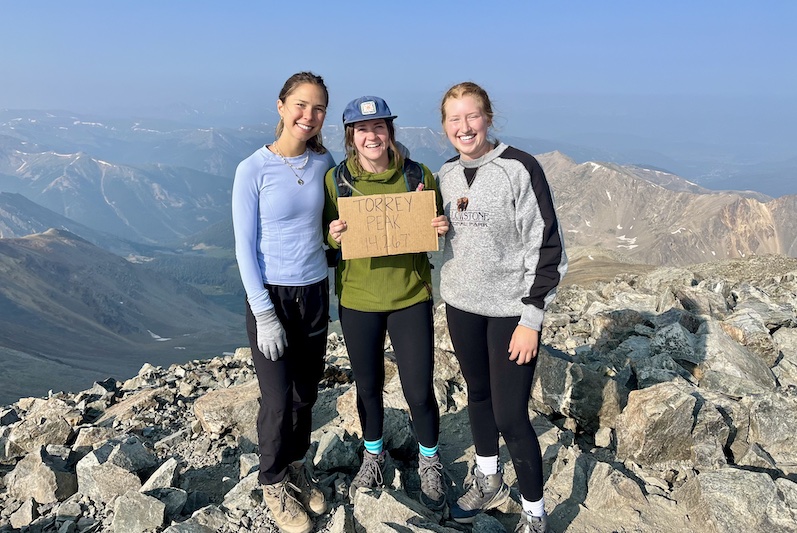
Grays and Torreys
Distance from Colorado Springs: 121 miles
Estimated Drive Time: 2 hours 15 minutes
Nearest Town to Trailhead: Silver Plume
Summits:
Grays Peak 14,275 feet
Torreys Peak 14,272 feet
This popular Front Range combo is less than an hour west of Denver and often hiked together by following the connecting saddle between them. Grays Peak is the highest point on the Continental Divide. The Class 1 hike covers 8.25 miles roundtrip and gains 3,600 feet. Start early to beat afternoon storms to both peaks — and to get a parking spot in the popular lot. Otherwise you’ll be hiking a few additional miles up the road. Not fun. You’ll also need a high-clearance vehicle to reach the summer parking lot. There’s a good chance of seeing mountain goats on these peaks; just give them plenty of room.
Other Colorado 14ers Near Colorado Springs
Mount Antero
Distance from Colorado Springs: 109 miles
Estimated Drive Time: 2 hours 15 minutes
Nearest Town to Trailhead: Nathrop, Buena Vista
Summit: 14,271 feet
Mount Missouri, Mount Oxford, Mount Belford
Distance from Colorado Springs: 116 miles
Estimated Drive Time: 2 hours 25 minutes
Nearest Town to Trailhead: Buena Vista
Summits:
Mount Missouri 14,071
Mount Oxford 14,158 feet
Mount Belford 14,202 feet
Mount Shavano and Tabeguache Peak
Distance from Colorado Springs: 117 miles
Estimated Drive Time: 2 hours 40 minutes
Nearest Town to Trailhead: Salida
Summits:
Mount Shavano 14,230 feet
Tabeguache Peak 14,158 feet
Huron Peak
Distance from Colorado Springs: 121 miles
Estimated Drive Time: 2 hours 45 minutes
Nearest Town to Trailhead: Buena Vista
Summit: 14,006 feet
Tips for Hiking Colorado 14ers
Colorado has plenty of 14ers accessible to beginners and plenty to challenge seasoned mountaineers. Even the “easiest” 14ers are challenging in elevations reaching above 14,000 feet. And the experience on any peak can range from a beautiful hike to a deadly ordeal on any given day. The key is being prepared and using good mountain judgment. Here are some basic tips.
Start Early
There’s no such thing as too early when it comes to summiting a 14er. Afternoon storms are common during summer in Colorado, and lightning at high elevation poses a deadly threat. The sooner you reach and leave the summit, the better chance of a successful summit. Storms can pop up at any time, but a good rule of thumb is to be off the summit no later than noon.
Respect the Weather
Check the forecast before you head out, and pay constant attention to the skies. Sometimes you can’t see storms building over the high ridge lines. If you have cell service, use an app like WeatherBug which has a lightning tracker than can alert you. If you hear thunder, head back down. Live to summit another day.
Use Good Gear
Be prepared for bad weather with clothes that will keep you dry, including a waterproof jacket and long pants. Have warm layers, including a hat and gloves. And make sure your boots or shoes provide the foot and ankle support and protection to stand up to shifting rocks and bruising boulders. Don’t forget the first aid kit and 10 Essentials. Hopefully you won’t need everything you carry, but in an emergency it can save your life. You can find an excellent packing list and guidance at 14ers.com.
Stay Hydrated and Fueled
Drinking water is your best defense to stave off altitude sickness. A hydration pack is the easiest way to carry water and sip on the go. On longer hikes, you may need to plan to filter or treat water from creeks to have enough. And bring enough food to fuel your body for the extra demands of hours of high elevation hiking.
Train for It
Hiking any 14er is physically demanding. With less oxygen in the air, you will feel the extra demand on your cardiovascular system. The fitter and more acclimatized to Colorado’s higher elevations, the better. Here are some great tips in our Get Fit for Colorado 14ers.
Know Where You’re Going.
Make sure you have a map, mapping app, compass and directions without having to depend on cell service, which you may or may not have in these sometimes remote areas. The 14ers.com website has directions with photos and topo maps for each peak that you can download and access offline, but things can still look different in real time in the wilderness. The O.G. guidebook Colorado’s Fourteeners by Gerry Roach is still an excellent resource for planning your routes too, but 14ers.com will provide more up-to-date trip reports and conditions.
