

Even in Pikes Peak country, Cheyenne Mountain State Park has managed to gain icon status of its own. The peak rises abruptly above southwest Colorado Springs, but it was the underground Cold War fortress of North American Aerospace Defense Command (NORAD) that put the peak on the national map—and international radar, no doubt. On top, the red lights of the antennae farm signal through the night like a cluster of silent, ever-present lighthouses. And in its shadow, a wide swath of the city, from neighborhoods to schools to countless businesses, bases its name and roots its identity on the famous craggy peak.
Yet Cheyenne Mountain’s summit has never been open to the public until 2018 (though some explorers have skirted private property for a bushwhacking ascent from Old Stage Road.) Now, thanks to the completion of the Dixon Trail in Cheyenne Mountain State Park, intrepid hikers and hardcore runners can journey to the top. For those up to the serious challenge, here’s what to expect.
First a word of reason—or warning: The trek to the top of Cheyenne Mountain is long and extreme. Liken it to a 14er ascent—a long 14er ascent. While you’ll “only” be standing at 9,300 feet on top, you’ll be logging about 3,500 feet of elevation gain to get there. You’re in for a round trip of around 15 to 17 miles or more, depending on how much exploring you do on top. And you do not want to be caught on top in a thunderstorm, so check weather forecasts and plan to head up and down early to stay ahead of afternoon storms.
Start your trek up Cheyenne Mountain at the Limekiln Trailhead parking lot. Follow the Talon Trail as several other trails branch off near its beginning. All trails in Cheyenne Mountain State Park are extremely well-marked. Talon will guide you 2.64 miles through the park’s lower meadows gradually, upward through rolling foothills covered with scrub oak, then steeply into dense pine forest. At about 2 miles, stay on the main Talon Trail past the first junction with North Talon Trail. But at the bench at 2.64 miles, take a right turn onto North Talon. You’ll ascend northward and switchback onto a more open, rocky ridge before encountering the start of Dixon Trail on your left.

It would be hard to miss the sign here letting you know you’re now on the new Dixon Trail and giving fair warning about the rugged terrain ahead. Dixon covers 4.5 miles before connecting with the Top of the Mountain trail loops, and from here you’ll gain 2,500 feet of elevation to the top.
The new trail begins on a fairly gradual ascent, though the ground is rocky and rough. Early on, the doubletrack follows the route used by Thomas Dixon for his family and cattle to reach their homestead cabin and grazing land on the southeast end of the mountain around 1917. On our preview hike, the trail bed was overgrown with summer vegetation, but future foot traffic should eventually wear the path smoother.

Bikes and horses are allowed on the first 2.5 miles of Dixon. In our experience, bikes are a benefit to speed up the early ascent and final descent of the long trek. But solid intermediate mountain biking skills are required. For the future, park manager Mitch Martin says he hopes to eventually develop a bikeable route to the top from Old Stage Road on the northwest side of the mountain.
Another sign 2.5 miles up the Dixon Trail (about 5.8 miles in total) signals that it’s time to park your bike or turn around your horse—from here it’s foot travel only. And it’s going to get steep in Dixon’s final 1.5 miles!
For now, pinflags and ribbons mark the route as trail crews from Rocky Mountain Field Institute, Friends of Cheyenne Mountain State Park and state park crews are still working to complete the trail. (Park officials ask that hikers avoid trail crews and stay uphill of any trail markings they encounter.)
The vegetation is dense here as you switchback and climb along a ridge that drops off on its eastern side. As you near a large rock pinnacle to your north, the trail sweeps west. This is where the trail gets extremely challenging, switchbacking and climbing steeply among large rock outcroppings. Power over several stone stairways, and know that gentler grades are coming soon.

Open sky will begin to appear on the horizon, and the landscape levels out into broad grassy meadows dotted with aspen trees. It’s an unexpected landscape compared with the rocky crags of Cheyenne Mountain visible from town. Pass the scattered and twisted metal of a T-33 training plane that crashed in 1957.

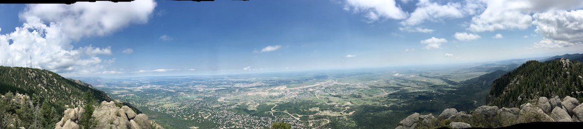
Here Dixon Trail intersects the Top of the Mountain trails. Follow the 1.4-mile Mountain Loop Trail through the meadows and into towering groves of aspen. With the Antennae Farm visible to the north, veer right and follow the trail uphill until you reach a large granite formation. Scramble about 20 feet up the clear chute on the left, and you’ll top out on Robber’s Roost. This is the vantage point you’ve come for, and the reward is sweeping views over the city, NORAD, Fort Carson and to Lake Pueblo and the Sangre de Cristos on a clear day.
To the northwest, the antennae farm is visible, as is the flagpole at The Broadmoor’s Cloud Camp and the recognizable crags known as the Horns. The dropoff to the east is sheer, reminding you of the ground you’ve gained for this spectacular view.

Before descending, take a rest on the large stone bench at the base of Robber’s Roost. The seat is a memorial to Mark Hesse, founder of the Rocky Mountain Field Institute, who mapped and designed these upper trails before his death.
To head back down, you can reverse course the way you came, or follow the .85-mile Dragon’s Backbone for a strenuous scramble along the eastern ridgeline before reconnecting with the Dixon Trail. Be prepared for a steep and rugged descent on Dixon. As you drop elevation rapidly, you’ll realize why you were working so hard on the way up—and why the rewards of this hike are all the sweeter for the effort required.
What to Know Before You Go
Where to Find It: Cheyenne Mountain State Park
Distance: 17-plus miles out and back from Limekiln Trailhead covering the entire trail network
Difficulty: Advanced / Extreme
Know Before You Go: Access to Cheyenne Mountain State Park is $7 for a daily pass or $70 for an annual pass, per vehicle. Dogs are not allowed.
How to Get There: From I-25 and S. Nevada Avenue, head south on S. Nevada and continue as the road changes names to CO-115. After approximately 5.4 miles, turn right on JL Ranch Heights Road across from the Fort Carson entrance. Continue straight through the traffic circle for .4 miles and enter Cheyenne Mountain State Park. Follow signs to Limekiln Trailhead, taking the first left to drop down into the parking lot.
Read about the making of the Dixon Trail in All Hail the Dixon Trail and Lake Moraine Trails—and the Devotees Who Built Them.
Read More
Trails: Hike the Ute Pass Trail
