

Do you see any over there?” I call to my teenage daughter from deep inside a tangle of scrub oak and pine branches.
“No … There!” she shouts pointing uphill from where we went downhill.
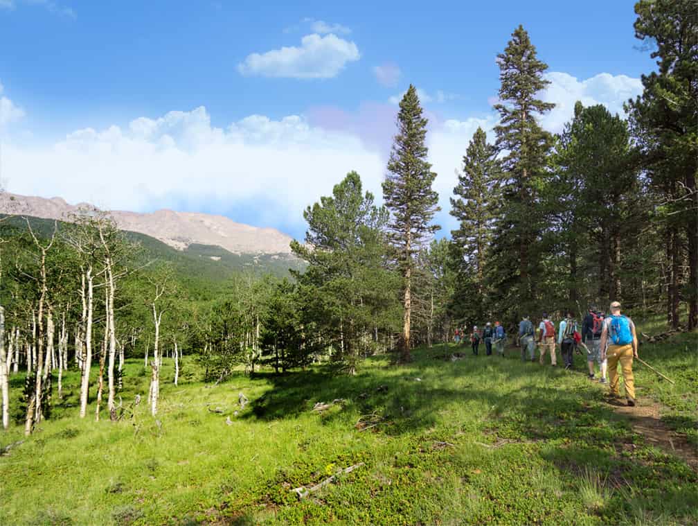
We’ve been granted access for an August preview of the Dixon Trail up Cheyenne Mountain, and our hike has turned into a hunt for small orange flags and ribbons marking the way. The long-awaited trail is nearly complete, except for this half-mile stretch that is still in the works.
The route is marked, but our progress has quickly gone from cruising to hide-and-seek with a furtive set of neon beacons. I’ve backpacked and bushwhacked in trailless areas in the Rockies and beyond, and this terrain is rugged, steep and thickly forested. As we pick our way through this rough section on the south side of Cheyenne Mountain, I’m struck with the overwhelming questions:, “Who builds these trails? And what does it take to create them?”

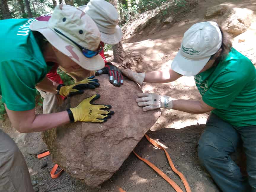
Turns out, an awful lot—of effort, planning, negotiation, time, money and, perhaps above all, volunteers. That’s especially true for a major trail like the Dixon Trail or the Lake Moraine Trail, which are both opening this fall after years of effort.
In the case of Dixon Trail, the project has been in the works since 2010 to connect the trail system of Cheyenne Mountain State Park with the top of its namesake peak. Hundreds of volunteers, mostly from the Rocky Mountain Field Institute (RMFI) and Volunteers for Outdoor Colorado (VOC) have put in approximately 16,500 hours of work since 2011.
Without them, the total price tag of about $150,000 between state funds and dollars raised by Friends of Cheyenne Mountain State Park would have ballooned to possibly prohibitive amounts, says park manager Mitch Martin.
While both of these trails will be iconic additions to our trail systems, that kind of large-scale effort is representative when it comes to building and maintaining the much-loved trails in our area.
WHERE WOULD OUR TRAILS BE without volunteers and organizations that coordinate and organize their efforts? “In poor shape, honestly,” says Molly Mazel, volunteer and partnership coordinator at RMFI.
“They wouldn’t even exist right now,” says Brian VanValkenberg, project coordinator for Friends of the Peak.
Susan Davies, executive director of the Trails and Open Space Coalition, shares a similar sentiment. “Without our Friends groups, the challenges we see would be tenfold,” she says. “I think we all think our trail system is amazing, but when you look at per capita funding, we aren’t even average in what we spend to maintain our parks, trails and open spaces—we’re below average, which is a little embarrassing. Our Friends Groups hide a lot of the warts by their ongoing efforts and maintenance.”
RMFI harnesses the power of about 2,000 volunteers each year, and TOSC works directly to foster and support the more specialized Friends Groups.
Name a large park or open space, and there’s most likely a Friends Group giving of personal time, money and energy to be caretakers and guardians of an outdoor space its members love. And they often channel their passion into new, sustainable trails that enhance the outdoor experience for themselves and others. (See “Your Friends and Mine” below.)

VanValkenberg’s path into trail work with Friends of the Peak (FOTP) is typical. “I found it by accident,” he says. Unemployed in 2009, he was hiking a lot to fill the time. That’s when he saw a notice at a trailhead for a volunteer workday and decided to sign up. “My first volunteer day on that site, I didn’t know people worked on trails. I just assumed they were always there,” he says. “I fell in love with trail work that day.”
Now as project coordinator for FOTP, he is responsible for planning, organizing and running the group’s 35 annual trail workdays on the Pikes Peak massif, along with recruiting new volunteers and handling other organizational duties. He’s an unpaid volunteer, but he negotiated a 30-hour work week for his day-job in order to devote regular time and energy to “maximizing human enjoyment while minimizing human impact” on Pikes Peak. The group works all over the mountain. And the ongoing Ring the Peak Trail originated with FOTP in the ’90s.
Similarly, the local mountain biking advocacy group, Medicine Wheel Trail Advocates, has been working on the Lake Moraine Trail—better known to mountain bikers as the Missing Link—since the ’90s. The goal was to establish a 4-mile connector between Barr Trail and Jones Park in upper Cheyenne Canyon.
Trail Committee member Doug Bursnall began showing up to move dirt on trail workdays about 20 years ago. In recent years, he has been involved with identifying, mapping, planning and leading new trail building projects, including the Lake Moraine Trail. “A new trail usually starts with ‘Wouldn’t it be great in this area to link these trails and improve this connection?’” Bursnall says.
But like other major trails, much of the Lake Moraine’s development timeline was spent on negotiating with landowners and stakeholders to secure the proper easements and permissions and to reach inclusion and alignment in master plans.
Delays for the trail included tightened watershed protection after 9/11, and Bursnall says it took about a year to obtain permission for the trail to cross the Cog Railway tracks. The group received a green light from landowner Colorado Springs Utilities, only to see it put on hold again for several years while the U.S. Forest Service closed the Bear Creek watershed to protect the threatened greenback cutthroat trout.
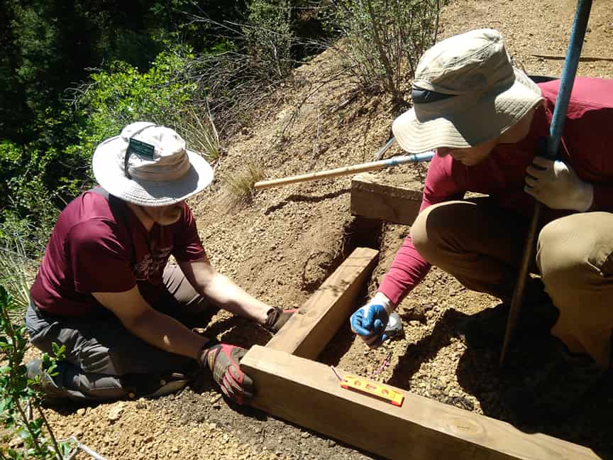
Medicine Wheel finally began cutting trail in 2017, using the Cog Railway to shuttle volunteers to the remote area for a couple workdays and hiring a trail-building contractor to make mechanized cuts. Of course, before that the advocates walked and rewalked the area to maximize the route for views and fun biking features like granite slabs, all while maintaining sustainable practices to prevent erosion and promote longevity. “Every 100 yards of trail is there for a reason,” Bursnall says. “It’s a laborious process.”
But the results will be long-lasting. “The outcome is the Missing Link will probably be there in 100 years,” Bursnall says.
Advanced mountain bikers are giddy about the now-realized iconic, backcountry options, including a 17-mile loop up Barr Trail, across a remote portion of Pikes Peak at elevations around 10,000 feet, and down through Jones Park and Cheyenne Canyon.
“We managed to include a lot of variety,” Bursnall says. “We stitched together lots of rock features through foliage and vegetation, lots of different types of geography. That can mean lots of enjoyment every time you go out there. Every half-mile something changes.”
MITCH MARTIN PUT REACHING THE TOP of Cheyenne Mountain in the state park’s master plan in 2010, soon after arriving at his post as park manager of Cheyenne Mountain State Park. By 2011, Volunteers for Outdoor Colorado began working on the lower portion of the trail. In 2014, RMFI began creating a 3- to 4-mile figure eight loop above, the Top of the Mountain Trail. The idea was to eventually meet in the middle.
“I always knew it would take time, maybe five or six years,” Martin says. “Now it’s been about seven or eight.”
The last hurdle was cleared early this year with an easement through private land to give the trail a more sustainable path.
Martin likens the destination to Barr Trail and the Incline “It is quite strenuous—difficult to extreme on its upper section,” he says. “But it will be extremely popular for folks looking for that.”
“It’s one of most exciting trail-building projects in years,” says Mazel of RMFI. “It’s the second-most iconic mountain on our skyline, and it’s just now open to public access. It’s a phenomenal peak and a wonderful climb.”
I agree. Back up on Cheyenne Mountain, my daughter and I finally clear the unfinished stretch of the Dixon Trail—that last easement to fall into place. Our path is clearer again through the wild hillside, but the going gets steeper with frequent switchbacks. We ascend several sets of massive stone steps that rise sharply.
Finally, we crest a ridge onto the top portions of this broad peak. What we find is unexpected. A grassy sloping meadow opens with wide gentle passage. Now I can see why two homesteaders, Thomas Dixon and Bert Swisher, grazed their cattle on these heights in the early 1900s—though I can’t imagine the effort to herd them up.
Aspen trees multiply into towering groves. We pass the scattered and twisted metal of a T-33 training plane that crashed in 1957. At the eastern edge, we reach a granite jumble. At its base is a thick stone bench, a fitting memorial to Mark Hesse, the founder of RMFI. This T.O.M. trail was his design, but he passed away before its completion.
A clear chute leads us up a 20-foot scramble to the top of a massive outcropping called Robber’s Roost. Martin had told me this is his favorite part of the Dixon Trail network, and Mazel calls it the “crown jewel.” This is the vantage point I’d hope for, and it’s every bit as rewarding. The view of the Springs is stunning, and Martin says you can see Lake Pueblo on a clear day. After seeing this mountain on the horizon for 20-some years, its as if I’ve stepped into the postcard view, it’s contours morphing into real life.
We don’t stay long on the summit. Storm clouds are looming, so we forgo the rest of the ridgeline loop and return the way we came. In another couple hours, we’ll drop sharply and find those flags more quickly. We’ll be glad to reach our bikes for a speedy descent back through the state park (the lower few miles of Dixon Trail will be open to cycling) and reach our car before an afternoon storm.
In total, we’ll have covered 16 miles—about 9 on bike, 7 on foot—and gained about 3,600 feet of elevation. The whole experience feels like a 14er ascent: long, rugged, steep, serious and rewarding. No, it’s not as lofty as those famed peaks, but its trailhead is less than 20 minutes from my door.
The New Big 3
Dixon Trail
6.6 miles including Top of the Mountain
Difficult to Extreme
Cheyenne Mountain State Park to Cheyenne Mountain summit
Lake Moraine Trail
4 miles
Difficult
Pikes Peak, Barr Camp to Jones Park
Ring the Peak
60-80 miles
Easy to Difficult
Circumnavigates Pikes Peak
Your Friends and Mine
If you use local trails and would like to give back, there are many Friends groups and stewardship organizations in our region to get involved with. Most host volunteer days where you might work on trail maintenance or construction, pick up trash or paint picnic tables. If trail work isn’t your thing, join a Friends Group board or make a contribution to support their work. These committed volunteers could use your help. Contact one of the following, or find a complete list of volunteer projects at openspacevolunteers.org.
- Friends of Cheyenne Canon
- Friends of Cheyenne Mountain State Park
- Friends of Red Rock Canyon
- Friends of Ute Valley Park
- Friends of Monument Valley Park
- Incline Friends
- Friends of the Peak
- Friends of Middle Shooks Run
- Friends of Blodgett Open Space
- Friends of Monument Preserve
- Black Forest Trails Association
- Friends of El Paso County Nature Centers
- Friends of Garden of the Gods
- Rocky Mountain Field Institute
- Colorado Mountain Club
- Volunteers for Outdoor Colorado
—Susan Davies, executive director, Trails and Open Space Coalition
Read More
Hike: Dixon Trail to the Top of Cheyenne Mountain
Best Trails: Must-Do Colorado Springs Hikes
3 Great Trails for Fun Family Hikes
10 Favorite Fall Hikes in and Around Colorado Springs
Best Beginner Mountain Biking Trails in Colorado Springs
